SOUTHERN COLORADO – In the mountains of Colorado, January proved to yield the best precipitation so far this water year, but it can hardly be viewed as a reprieve from the tenacious pattern of dry weather. At 70 percent of average, January precipitation was only slightly better than October at 69 percent. Snowpack too saw minimal improvement across the state up from 54 percent of normal last month to now 59 percent of normal on the first of February.
“Nearly one quarter of the almost 200 snow monitoring sites across our network recorded snowpack at the lowest or second lowest levels on record,” said Brian Domonkos, Colorado Snow Survey Supervisor, referring to the network of USDA Natural Resources Conservations Service SNOw TELemetry and Snow Course sites nestled in the mountains of Colorado. With nearly one third of the typical winter season remaining, a major shift in weather patterns will be needed to make significant improvements, particularly in Southern Colorado.
Highlighting the below normal conditions, SNOTEL sites within the Rio Grande basin indicate snowpack is the lowest in recent history at 31 percent of normal. Meanwhile the SNOTEL sites in the combined San Miguel, Dolores, Animas and San Juan River basins observe the lowest standing year-to date precipitation at 29 percent of normal. Northern Colorado however is performing considerably better. On the high side, snowpack in the North Platte River basin is at 82 percent of normal and in the South Platte River basin, which is home to much of the Denver Metro area, snowpack is at 80 percent of normal and year-to-date precipitation is much closer to normal at 98 percent.
Areas of Colorado such as Wolf Creek Pass and Red Mountain Pass in the San Juan Mountains typically boast five to six feet of snow in early February, but currently report only two to three feet. Domonkos adds, “What’s more concerning is the considerable number of mid to lower elevation monitoring sites that have little to no snow.” Most of these sites are located in the southern half of the Colorado. Reservoir storage across the state is at the highest January levels in many years, at 115 percent of normal and will provide some assistance to spring and summer runoff where snowpack is well below normal. While some streamflow forecasts in the South Platte and Upper Colorado River basins are projected to produce runoff within the range of normal, far more rivers and streams throughout the rest of Colorado are forecasted to provide below normal to well below normal runoff this spring.
ARKANSAS RIVER BASIN
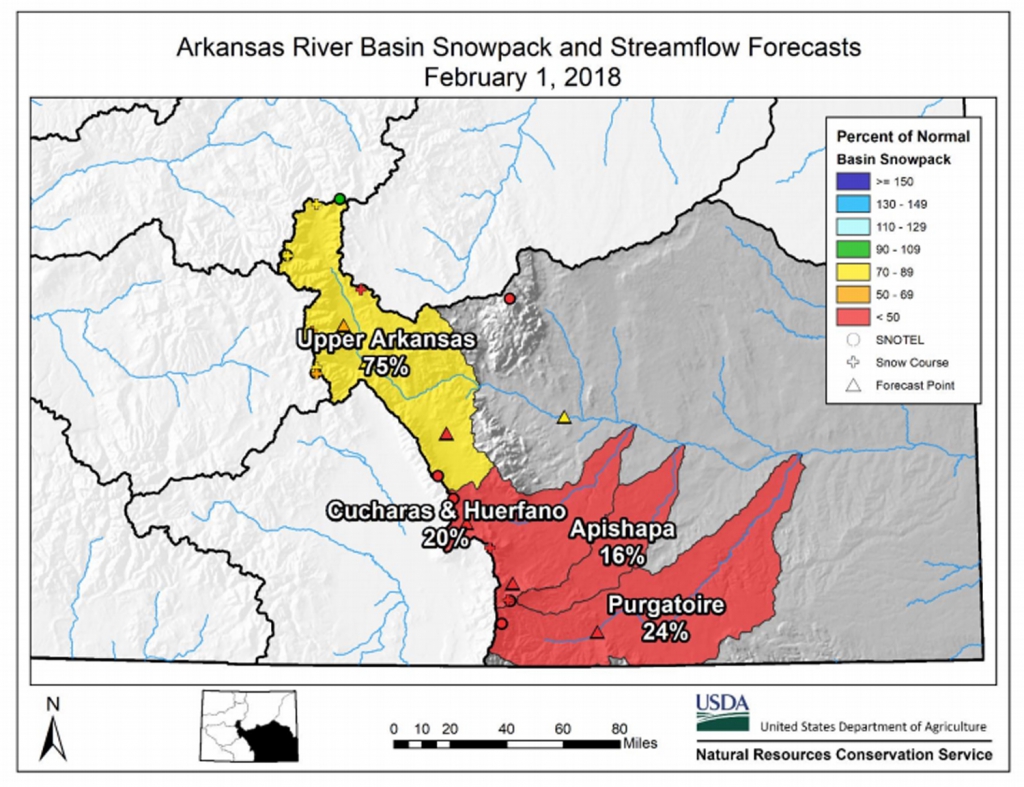
Snowpack in the Arkansas River basin is below normal at 55% of the median. Precipitation for January was 58% of average which brings water year-to-date precipitation to 56% of average. Reservoir storage at the end of January was 138% of average compared to 99% last year. Current streamflow forecasts range from 80% of average for the Arkansas River at Salida to 20% of average for Grape Creek near Westcliffe.